

Tuesday, November 29, 2011

Monday, November 14, 2011
Reference Book for Civil Services Examination
Topic-wise reference books on General Studies
To be a part of the Indian Civil Services is a dream nurtured by most of the young brains in India. It is one of the most challenging exams in India. Entry to this career is through the Indian Civil Services Examination conducted by Union Public Service Commission. This is a two tier exam: One is Preliminary and other is Mains and Interview conducted in three stages respectively. From the students' per-spectives we give below a list of preferable and useful reference books and reading resources for the General Studies:
Indian History & Culture
● Indian History: NCERT ( + 2 levels)
● Modern India: Bipan Chandra (India's Struggle for Freedom)
Geography
● Physical Geography of India: NCERT (Class Vl- XII)
● A Good School Atlas: The TTK World Atlas
● India: A Comprehensive Geography 2nd Edition 2006 Reprint 2008 by DR Khullar
● Magazines: Kurukshetra, Yojana
Indian Economy
● Evolution of Indian Economy: I C Dhingra; NCERT ( +1level)
● Indian Economy: Mishra & Puri (28th Revised Edition)
● Indian Economy: Uma Kapila (Indian Economy: Performance & Policies/Academic Foundation 2010-11/Tenth Edition
● Indian Economic Survey
● Magazines & News paper: The Economic Times, Yojana
Social and National Issues
● Social Problem in India by Ram Ahuja
● Magazines: Yojana, Kurukshetra,
Indian Polity● Indian Political System: NCERT (+1 level)
● Introduction to the Constitution of India: D D Basu (20thEdition Reprint 2010)
● The Constitution of India: PM Bakshi (10 Edition)
● Our Constitution: Subhash C Kashyap
● Indian Polity. Lakshmikant (3rd Edition)
● Magazine: Frontline
Science & Technology
● NCERT: (10 levels): Science including Biology (+2 levels)
● Science and Techno1ogy in India: Spectrum
Statistics
● Elementary Statistics: NCERT (+1 level)
● Spectrum Book (Statistical Analysis: Graphs and Diagrams)
Current News
● The Hindu, Indian Express
● Frontline, Outlook
Mental Ability & Verbal Reasoning● Verbal Reasoning-by RS Aggarwal
● Quantitative Aptitude- by RS Aggarwal
● Non Verbal Reasoning- by RS Aggarwal
Other Books● India Year Book
● The Pearson General Studies Manual
● Manorama Year Book
Citizens Right to Grievance Redress Bill 2011
The Citizens Right to grievance Redress Bill 2011 marks the next milestone in the UPA government’s mission to enact a series of rights based legislations. Drawing on the framework of the Right to Information Act, the objective of this Bill is to ensure that the common man receives quick and efficient delivery of the goods and services to which he is entitled and which may have been delayed for any reason whatsoever.
The other objective of this Bill is to ensure that a person who is denied a public good or service to which he is entitled is able to take action against the person who is denying that service on a mala fide ground (such as a demand for a bribe in exchange for the service).
To this end the Bill directs all public authorities to draft and publish a ‘Citizens Charter’. This document contains a list of functions and obligations that the public authority can be reasonably expected to fulfil. In addition to this the name and addresses of individuals responsible for the delivery of goods or the rendering of services is to be provided as well. An illustrative list of contents for the ‘Citizens Charter’ is provide in the Bill itself. This Charter is to be updated annually.
The Bill establishes new authorities at the level of the Block, District, State and the Centre. A person can file a complaint with the ‘Grievance Redress Officer’ at the level of the concerned department itself. Within fifteen days of the filing of this complaint the aggrieved individual is to receive the public good or service he was denied. If his complaint is not addressed within fifteen days the same is automatically escalated to the level of the Head of Department along with an ‘Action Taken Report’ detailing the reason for the lack of action on the complaint. The Head of Department has to resolve the complaint within thirty days of receipt.
Appellate bodies to hear appeals from the Head of Department have been constituted at the level of the State and the Center. If an official is found to have denied a service unfairly or in a mala fide manner then penalties can be imposed against him.
In addition to this a new body called the ‘Information and Facilitation Center’ shall be established within each public authority to provide aid to any individual who wishes to file a complaint. This body along with the Grievance Redress Officer shall provide all necessary education and assistance to an aggrieved person.
Where it appears to the Head of the Department of the Public Authority that the grievance complained of its indicative or representative of a corrupt act on the part of the individual officer then it shall record the evidence in support of such conclusion and shall initiate criminal proceedings against the official.
The existing mechanisms have proven to be inadequate when it comes to redressing the grievances of citizens. Most of them are housed within the public authority complained against, thereby leading to an ostensible conflict of interest.
The Bill significantly strengthens the ability of the common man to demand delivery of public goods and services. It further promises to ensure greater transparency and accountability in the system by eliminating avenues for bureaucratic delays.
Friday, November 11, 2011
Role of Governors in Tribal Areas
TRIBAL AFFAIRS
Scheduled Tribe community constitute more than 8 per cent of our national population and are still waiting to receive the benefits of freedom even after a lapse of more than sixty years since we achieved independence. The tribal populations are placed at the lowest rungs of the society in terms of various developmental indicators. The lowest literacy rates, high drop-out rates, widespread poverty, high infant and maternal mortality rates, an alarmingly high incidents of malnutrition, the absence of basic facilities and scarce livelihood means have deprived them the opportunity to a dignified livelihood among the fellow citizens of our country. It is not merely a matter of coincidence that Left-Wing Extremism is prevalent in the Schedule V areas while the insurgent movements have confined themselves to Schedule VI areas. It is necessary for us to introspect and get to the bottom of the reasons and causes which has led us to this place and situation.
Despite the various efforts that have been made a large gap still remains to be bridged. The alienation of the tribal population has been growing rapidly mainly because they are being dispossessed of all their livelihood resources. The diversion of forests and common property resources for the use of non-forest purposes has resulted in the displacement of tribals from their homeland. The general apathy of official machinery, the escalating assaults related to their existing rights, the growing clout of market forces, the threat of mining and of course, the meager advancement through planned development efforts have been responsible for the growing unrest amongst this most oppressed and depressed class of people.
Towards Empowering STs
The Ministry of Tribal Affairs has the responsibility of reducing these glaring gaps by supplementing the efforts of the nodal Ministries in the Government and of the State Governments through need-based interventions. It has taken up a series of programmes and schemes to empower the tribals socially, politically and economically. However, in this context, it is pertinent to mention that Governors have a vital role to play. The Governors have been endowed with certain special powers with regard the Fifth Scheduled Areas. The judicious use of the provisions enshrined in the Fifth Schedule of our Constitution will certainly make a very positive impact on the tribals living in these regions.
Under the powers conferred by the Fifth Schedule, the Governors can not only direct that any particular law or part thereof may not apply to a Scheduled Area that can also make regulation for good governance and peace in these areas. The Governors can intervene in areas relating to-Prohibition or Restriction of the transfer of land by or among Scheduled Tribe members; regulation of allotment of land in such areas; and the regulation of money-lending activities. The Governor has basically been given the legislative power to make regulations for the “peace and good government of any area which is a scheduled area.” The peace and good government are words of very wide import and give wide discretion to the Governor to make laws for such purpose.
One can recall the observations made by the President at the Governors’ Conference held on 16th and 17th of September, 2008 regarding the need for an authoritative legal opinion with respect to powers of Governors under the Fifth Schedule. The matter has since been examined in consultation with Ministry of Law and Justice and Attorney General of India has opined that “in performance of the functions and exercise of the powers under the Fifth Schedule, the Governor is not bound by the aid and advice of the Council of Ministers of the State”. The provisions of Articles 244(1) and 244 (2) which provide for the administration of the Scheduled Areas within a State in accordance with a Fifth & Sixth Schedule respectively emerge from the Excluded and Partially- Excluded Areas as envisaged under the Government of India Act, 1935.
Implementation of PESA
The focus of the the Panchayat Extension Scheduled Areas Act, 1996 (PESA) is to recognize the Gram Sabha as a key unit of governance in the Scheduled V areas as this would in turn give the people a control over their own resources. The Gram Sabhas under PESA are meant to be competent to safe-guard and preserve the traditions of their people, community resources and customary mode of dispute resolution. The Gram Sabhas are to approve plans, select beneficiaries and give utilization certificates to the Gram Panchayat. The Gram Panchayats further have - right to mandatory consultation in matters of land acquisition, resettlement and rehabilitation; right to recommend prospecting licenses/mining leases for minor minerals; power to prevent alienation of land and restore alienated land; power to regulate and restrict sale/consumption of liquor; power to manage village markets, control money lending to STs; ownership of minor forest produce; control over institutions and functionaries in all social sectors; control over local plans and resources for such plans including TSP, etc and planning and management of minor water bodies.
The purpose of implementing PESA in the Scheduled V Areas is to promote self-governance in order to address the problem of exploitation. But unfortunately, the implementation of PESA has not been satisfactory despite the guidelines that have been issued in this regard to State Governments by the Ministry of Panchayati Raj.
Key Issues under PESA
A process of notifying villages as PESA and constituting Gram Sabhas accordingly needs to be undertaken at the earliest. Applications may be invited from the community and inquired into by an official designated by the State Government in terms of whether or not the villages proposed are as envisaged in PESA. Villages proposed as per PESA may be so notified and a Gram Sabha constituted for each village.
Recently, Ministry of Panchayati Raj has commissioned studies on laws and rules in each State, pointing out the gaps and possible new formulations. These have already been shared with the State Governments of Jharkhand, Chhattisgarh and Orissa. Studies of remaining States will also be shared. These studies can be used for making necessary amendments.
Ministry of Panchayati Raj has framed model rules which can be used as a reference point for making rules under the relevant State Acts so that the procedures to be followed by Government functionaries are clear.
The National Institute of Rural Development (NIRD) has recently prepared a training module on PESA and shared it with the States. States may adapt this training module as per their needs and intensify their efforts in capacity building.
Gram Sabha and FRA
The Gram Sabha is a congregation of the entire body of a village and cultivating this basic unit will give an opportunity to all citizens including those who have not been elected to any post to participate in the process of development and governance. It should be our earnest endeavor to ensure that the people who have been neglected for several years are made to feel that they are also a part of our democratic process.
Forest Rights Act for Scheduled Tribes and other Traditional Forest Dwellers is a land mark legislation which gave a new hope to millions of tribals who have been living in forests for generations. For the first time ever, this Act seeks to recognize and regularize the pre-existing rights of tribals living in the Scheduled Areas. The Governors of the Fifth Scheduled States may ensure the speedy implementation of the Forest Rights Act through their respective State Governments as this would reduce a lot of tension arising out of land related issues in these areas. Under the provisions of para-3 of the Fifth Schedule wherein the Governors of Scheduled Areas States are expected to make an assessment of the administration of the Scheduled Areas and send an annual report to the President of India. The said reports should also deal with the observations made by the Tribal Advisory Council of the State and indicate steps taken with respect to the recommendation of the TAC. As per the records available with the Ministry of Tribal Affairs, the Governor’s Report of the administration of the Scheduled Areas for the year 2009-10 is yet to come from some States. It is urged that the Governors to send this annual report in a timely manner as this would help the Ministry to evaluate the progress that has taken place in the Scheduled Areas of the States.
The Sixth Schedule of the Constitution among other things provides for the administration of tribal areas through District/Regional Councils in the States of Assam, Meghalaya, Mizoram, Tripura in exercise of powers given under the Constitution, the Governors of the Sixth Scheduled Areas may hold consultations with State Governments and Councils to emphasise need for having the democratic and decentralized governance at the village level. Some of the provisions that could be considered may include (i) creation of elected Village Councils where they do not exist; (ii) making Village Councils answerable to Gram Sabha; (iii) recognize Gram Sabha under the law and specify their powers and functions; (iv) mandatory and regular election for the Village Council through the State Election Commission and (v) vesting of more powers to Village Councils and Gram Sabha.
These measures will help in strengthening the democratic process and the empowerment of women which would consequently result in improved health services, education and nutrition programmes. This would also increase transparency in the process of planning, implementation and monitoring the developmental programmes. The Ministry of Tribal Affairs is actively pursuing the matter relating to the constitution of a Cell in the Governor’s Office with the State Governments in order to handle the constitutional responsibilities of the Governor relating to the rights of Scheduled Tribes in the Scheduled Areas. It is hoped that these Cells are constituted by each State by the end of current financial year. It is high time that the Governors should personally intervene when necessary to deliver to the tribal population the dreams of our Founding Fathers.
Major Heavy Metal Contaminated Sites in India Factsheet
| Chromium | Lead | Mercury | Arsenic | Copper |
| Ranipet, Tamil Nadu | Ratlam, Madhya Pradesh | Kodaikanal, Tamil Nadu | Tuticorin, Tamil Nadu | Tuticorin, Tamil Nadu |
| Kanpur, Uttar Pradesh | Bandalamottu Mines, Andhra Pradesh | Ganjam, Orissa | West Bengal | Singbhum Mines, Jharkhand |
| Vadodara, Gujarat | Vadodara, Gujarat | Singrauli, Madhya Pradesh | Ballia and other districts, UP* | Malanjkahnd, Madhya Pradesh |
| Talcher, Orissa | Korba, Chattisgarh | | | |
Data of CPCB show that Gujarat, Maharashtra and Andhra Pradesh contribute to 80% of hazardous waste (including heavy metals) in India.
The Industrial Sources of Heavy Metals
Metal Industry
Chromium (Cr) Mining, industrial coolants, chromium salts manufacturing, leather tanning
Lead (Pb) lead acid batteries, paints, E-waste, Smelting operations, coal- based thermal power plants, ceramics, bangle industry
Mercury (Hg) Chlor-alkali plants, thermal power plants, fluorescent lamps, hospital waste (damaged thermometers, barometers, sphygmomanometers), electrical appliances etc.
Arsenic (As) Geogenic/natural processes, smelting operations, thermal power plants, fuel burning
Copper (Cu) Mining, electroplating, smelting operations
Vanadium (Va) Spent catalyst, sulphuric acid plant
Nickel (Ni) Smelting operations, thermal power plants, battery industry
Cadmium (Cd) Zinc smelting, waste batteries, e-waste, paint sludge, incinerations & fuel combustion
Molybdenum (Mo) Spent catalyst
Zinc (ZN) Smelting, electroplating
Sunday, November 6, 2011
GEOGRAPHY TERMINOLOGY
Acid precipitation (Acid Rainfall): is now regarded as a serious problem in some European and Asian countries, the main cause and source of which is emissions of sulphur oxides and nitrogen oxides from thermal power plants and burning of fossil fuels. These oxides dissolve in atmospheric water vapour and fall back on earth as acid rainfall. Acid rainfall can cause destruction of crops and trees; destruction of fish; and damage to buildings.
Agronomy: Soil management and production of field crops is known as Agronomy.
Aleurone layer: is that part of the grain in cereals where much of the protein lies.
Alluvial soil: is the richest and most fertile soil of India spread over large areas in northern plains of India.
Arakan Yoma: is the extension of the Himalayas located in Myanmar.
Asthamudi Lake: is located in Kerala State.
Bailadila: in Bastar district of Madhya Pradesh, is known for its wealth of Manganese.
Barhara (Tribes): The Barhara tribes mentioned in the Mahabharata who had settled in the north-western regions of India, are associated with—(1) Ambashthas (a mixed Mongolian Aryan race); (2) Gandharas (Afghans); (3) Pavas.
Bhabhar region: in south of the Shivaliks, is an example of Piedmont situation i.e., belonging to or related to the foot of a mountain.
Bushmen (Tribes): They live in the Kalahari desert. They are probably the descendants of the earliest inhabitants of Africa. They rank among the most uncivilized and backward peoples in the world. Their food consists almost entirely of meat, often raw or decomposed, and in times of scarcity they will eat insects, snakes etc.
Cardamom: Karnataka is the largest producer of cardamom. India is the largest exporter of cardamom in the world.
Chinook: Warm, dry wind experienced along the eastern side of the Rocky Mountains in Canada and the U.S.A.
Climograph: is a graphical representation of the differentiation between various types of climate. It reveals the type of climate at a glance—a climograph showing wet bulb temperatures and relative humidities which are high, for instance, depicts a constantly hot damp climate.
Coastline of India, Length of: The length of India’s coastline is 7,516 km and its territory includes 1,256 islands. Tamil Nadu has the longest coastline in India.
Cosmic year: One cosmic year is equal to the time taken by the sun to complete one orbit around the galactic centre.
Cotopaxi: is the highest volcano in the world. It is situated in Ecuador.
Date Line, International: International Date Line is an internationally agreed line drawn parallel to the 180° meridian. It divides the Pacific Ocean into two equal parts. A crossing of the International Date Line entails repeating one day when travelling westwards.
Detroit of India: Pithampur in Madhya Pradesh, where a large number of automobile industries have been set up, is called the “Detroit of India”.
Doldrums Belt: is a zone of the tropics where the calm lasting for some weeks prevails, broken at times by erratic squalls and baffling winds. It is an area of low pressure. The wind system in the Equatorial areas is known as doldrums.
Dust Devil: is a dusty whirlwind normally a few feet in diameter and about 100 feet tall, sometimes also wider and higher.
Earth mass: The mass of the earth is about 81 times that of the moon.
Earth’s core: is mainly composed of iron and nickel. Lithosphere is the innermost layer of the earth.
El Nino: is the weather phenomenon brewing in the tropical Pacific Ocean. It is the largest climate event of the 20th century setting off more global disasters than ever before. El Nino is warming of the waters off Equatorial South America which causes climate abnormalities around the world. The impact can be flooding drought in California, Brazil, Africa and Australia, severe storms in the Central Pacific and a decline in hurricanes hitting the south-eastern United States.
Exfoliation: This type of weathering is common both in the cold as well as in the hot climate regions.
Fertilizer plant, First: The first fertilizer plant in India was set up at Sindri (Bihar).
Garo (Tribes): Garos are the tribe of Garo Hills in Meghalaya.
Glacial lake—example in India: Dal Lake in Srinagar.
Great Circle: A circle on the earth’s surface whose plane passes through its centre, and bisects it into two hemispheres. Two opposing meridians together form a Great Circle. The shortest distance between any two points on the earth’s surface is the arc of the Great Circle which passes through them. 0° latitude forms a Great Circle. (The latitude or longitude 75°W should be combined with 75°E to obtain the Great Circle).
Horse Latitudes: Sub-tropical belts of high atmospheric pressure over the oceans situated in both hemispheres. These are called Belts of Calm between regions of the Trade Winds and Westerlies of higher latitudes.
Hydroponics: means cultivation of the plants without use of soil.
Hyetology: is the study of rainfall.
Indira Point: in Andaman and Nicobar Islands is the southern-most tip of India.
Irrigated area, Indian State having largest: The Indian State with the largest irrigated area is Uttar Pradesh.
Jhum: It is a slash and burn method of shifting cultivation (called jhum) practised on rainfall-bed slopes of forest hills and dales in Arunachal Pradesh.
Kandla: is a sea port situated at the head of the Gulf of Kuch in Gujarat State. It was the first port to be developed after independence. It has a free trade zone.
Khonds (Tribes): were primitive tribes living in Orissa.
Kikuyu (Tribes) : are a race of Bantu negroes who live to the north of Mount Kenya. These people combine agriculture with pastoralism.
Kirghiz (Tribes): of Central Asia are an example of people adapted to a grassland environment. The Kirghiz are pastoral nomads who move from pasture to pasture with the flocks and herds of horses, camels, oxen, sheep and goats. Meat forms only a small portion of their food. The Kirghiz are fearless horsemen, and even their children are expert riders
Lambadies (Tribes): are concentrated in Karnataka.
Lapse Rate: is the rate of change in temperature with increase of altitude.
Laterite soils: Laterite soils are formed by the weathering of laterite rocks. These can be distinguished from other soils by their acidity. Laterite soils are generally poor on the higher levels and cannot retain moisture. In the plains, however, they consist of heavy loams and clay and can retain moisture. Laterite soils occur in Madhya Pradesh, Assam and along the eastern and western Ghats. Tea plantation require acidity which is there in the laterite soil. It is, therefore, common in these areas.
Loams (loamy soil): Amixture of sand, clay and silt is known as loamy soil. Loams are formed where the soils have equal proportion of sand, silt and clay.
Local winds and their areas: Khamsin—Egypt; Zonda—Argentina; Santa Ana—California; Simoon—Iran.
Lushais (Tribes): are tribes of Mizoram.
Mansarover Lake: is in Tibet. Near it, the rivers having their source are the Brahamputra, the Sutlej and the Indus.
Maoris (Tribes): are the original inhabitants of New Zealand.
Masai (Tribes): of the East African plateau are the example of pastoral peoples. They are a tall, strong, warlike race, partly negroid in type. They treat their cattle with great respect and affection and do not kill them for food or for sale as meat.
Monsoon in India: is related to differential heating and cooling of the huge landmass of Asia and the Indian Ocean and the origin of cyclones in the Bay of Bengal. The term Monsoon was introduced by the Arabs.
Munda (Tribes): are mostly located in Madhya Pradesh.
Negritos (Tribes): are the ancient tribes of Andamans.
Nutrification: is the process of conversion by action of bacteria, of nitrates in the soil.
Onges: are tribes of Andaman and Nicobar Islands.
Oraon (Tribes): are aboriginal people of the Chhota Nagpur region in the State of Bihar. They call themselves Kurukh and speak a Dravidian language.
Pangong Tso: is one of the world’s highest and brackish lakes in Jammu & Kashmir.
Pressure zones on earth: are created due to differential heating of the earth’s surface by the sun.
Proxima Centauri: is a star nearest to the earth.
Rare earths (Or Lignite and Monazite) : are found on the beaches of Kerala and Tamil Nadu. Monazite is an ore of thorium.
Roaring Forties: are westerly winds.
Saddle peak: is the highest peak of Andaman and Nicobar islands, located in Great Nicobar.
Savannas: are found between latitudes 5° and 20° North and South of Equator. These are tropical grasslands bordering the equatorial forests in each hemisphere. The Llanos and Pampas of South America are chief examples of Savannas but extensive Savannas are in Africa. Savanna grasslands are also found in Australia. The three-tier growth of vegetation is found in these regions. The natural vegetation of Savannas consists of tall grass.
Selvas: The rain forest of Amazon basin is called Selvas. These are rainy tropical forests..
Semangs (Tribes): are tribal people living in Malaysia.
Spring Tides: are caused when the sun and the moon are in a straight line. The tide on its maximum height is known as Spring Tide.
Taiga Belt: lies between the Tibet-type climate and the Tundras.
Telegu Ganga Project: in Tamil Nadu envisages optimal use of surplus water of the Krishna river. It is a joint venture of Tamil Nadu, Andhra Pradesh and Karnataka.
Time Zone: A zone on the terrestrial globe that is 15° longitude wide and extends from pole to pole and within which a uniform clock time is used. Time zones are the functional basis of standard time. The world is divided into 24 time zones.
Tsunamis: are huge sea waves caused by earthquakes.
Willy Willy: is a tropical cyclone of the north-west Australia.
Friday, November 4, 2011
HIMLAYA MOUNTAIN RANGE
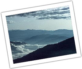
The Central Himalaya are the crown of Uttar Pradesh and stand guard to the Upper Ganga plain. The mighty Himalayas standing on the northern frontier of UP are highly rugged and have difficult and precipitous slopes, horned peaks, serrated crests of high ridges, cirques and glaciers, snow clad slopes, hanging valleys, cascades of sparkling water supplied by melting ice, torrential rapids, deep canyons, roaring streamlets, huge boulders and glistening lakes.
When one happens to be in these environs, a deeply hidden longing becomes very pronounced upon gazing at the Himalayan peaks of Uttar Pradesh... the longing to reach up to those awe-inspiring, wonder-filled and dizzy heights that exude a joy on their own.
These cloud-kissing, skyscraping peaks tower serenely above all else creating a picture as only the most adept of all artists: Mother Nature could paint.
The scenic beauty and the grandeur of the Central -Himalayan ranges and the remote location of the religious temples like Badrinath, Kedarnath, Gangotri and Yamunotri have excited the interest of people since very early times. In the Pauranik literature, this part of the Himalayas bears the name of Uttara-Khand or Kedar-Khand. Ved Vyasa being attracted to the scenic beauty and religious importance of this region wrote an Upa-Purana about it.
The region and especially the peaks are abundantly referred to in historical literature, indicating that great saints, travellers and kings frequently visited this part of the Himalayas. In fact every peak, rock and rivulet is dedicated to some deity or saint and has an appropriate legend attached to it.
HIMALAYAN PEAKS OF UP HILLS
The lofty Himalayan peaks rising to dizzy heights have a complex physiography falling into three regions. The topography of rugged land and dangerous slopes have often beckoned the spirit of the adventurers. No wonder, many of the peaks have been successfully scaled by mountaineers from the world, over the years.
U.P. Himalaya includes the Himalayan basins of the Yamuna, the Ganga, the Ramganga and the Kali or Sarda. The tangential as well as vertical movements of the terrain have given rise to complex physiography of the region. Thus, the topography consists of highly rugged land with precipitous slopes which, in accordance with its structure and relief, is further subdivided into 3 major physiographic regions.
1. Himadri (Greater Himalaya)
i) Himadri Ranges
ii) ii)Himadri Valleys
2. Himanchal (Lower Himalaya)
i) Himanchal ranges and hills.
ii) ii)Himanchal valleys and lake basins.
3. Shivaliks (Sub-Himalayan tract)
i) Duns
ii)Shivalik ranges
HIMADRI
Himadri, the great Himalayan zone forms the northern boundary of the region stretching in North West South East direction, the average width of the Himadri is about 50 kms. The average altitude of the zone varies from 4,800mts. to 6,000 mts. The important peaks of this region are: Nanda Devi, Kamet, Bander Punchh, Kedarnath, Chaukhamba, Dunagiri, Trishul and Nandakot. Almost all these peaks are glacier-garlanded and are separated by transverse gorges of the Alaknanda, the Bhagirathi and the Dhauli Ganga. The important glaciers of the Kumaon Himadri are: Gangotri, Chaturangi, Bhagirathi, Kharak, Satopanth, Kamet, Milam and Pindari.
HIMANCHAL
 The central zone of the Himalaya located between the Himadri and the Shivaliks in the north and south respectively, is known as the Himanchal. With an approximate width of 75 kms, the Himanchal is a massive mountainous tract, separated in the south by the 'main boundary fault.' The whole zone is mainly composed of metamorphic rocks varying in age. The average height of the ranges in this zone varies from 1,500 mts. to 2,700 mts. and of the valley bottoms between 500 mts. and 1,200 mts.
Most of the valleys of the important rivers form a wide course. The rivers cut through barriers to drain out lakes, such as the ones in the vicinity of Baijnath in the Garur valley, Agastmuni (Mandakini valley) and around the basins of the Bhim Tal and the Naukuchiya Tal in Nainital District.
SHIVALIKS
A long chain of narrow and low hills, from 300 mts. to 600 mts. in elevation, lie almost parallel to the main ranges of the Himanchal.
The hill slopes are steeper on the southern side while on the northern side the slope is gentler and merged to flat floored structural valleys called 'duns'. The important duns are Dehra, Kohtri, Chaukham, Patti and Kota. The dun of Dehra (Dehradun) is the biggest with a length of 35 kms. And width of 25 kms.
SOME IMPORTANT PEAKS
Lord C. Schuster said of mountains "Always alluding, though they flout you, always dear, though they slay you, they give you strength & friends & happiness; & to have known them is indeed a liberal education. "
NANDA DEVI
Altitude: 7,817 mts.
Nanda Devi, the highest of the Garhwal peaks, which literally means 'Blessed Goddess'. It is considered the pearl of the Himalayas because of its loveliness. The graceful symmetry of its double peaks, the main and the east, thrusting themselves up to the sky, is indeed a visual treat-a rare example of perfect twin peaks. It would perhaps be strange if a mountain of such beauty were not an object of worship. In fact, since ancient times, inhabitants of the region have revered this mountain as a dwelling place of the Gods. The names for mountains and passes in the area often have religious meanings.
Like Kamet, Nanda Devi refused for years to yield to the many climbers who tried to overcome her. It is extremely difficult even to approach her foothills, the entrance to which is guarded by long, deep gorges. After several failures, one party finally succeeded in crossing these gorges and in 1934, entered the south foothills of the mountain.
BANDAR PUNCHH WEST
(White Peak)
Altitude: 6,316 mts.
This peak lies to the South West of Kalanag. In June 1950 JTM Gibson with Tensing Norgay (of Everest fame) attempted it from the south. They were defeated by vertical walls of ice gullies. Once climbed after avoiding the crevasses and on finally reaching the corniced top one can get a view of the steep drop to the southern valley, adjoining ridge of Bander Punchh and distant Swargarohinl peaks.
DEVTOLI
Altitude: 6,788 mts.
The peak lies to the southern most point on the inner wall of the Nanda Devi Sanctuary. It is on the South West ring of peaks in line with Maikroli & Mrigthuni (6,803 & 6855 mts. respectively).
It is at the Junction where the ridge from the Devistan joins in the south, the ridge between Maikroli & Mrigthuni. So it stands overlooking the sanctuary in the east, Trishul Nala in the west & Sunderdhunga - Tharkot directly below to the south.
Panchchuli Peaks
Altitude : 6,904 mts
It is believed that this is the place Five chulis' cooking hearths) where the Pandavas cooked their last meal on the way to heaven They are majestic and form a famous barrier between Darma and Gori valleys. H. Ruttledge recceed it in 1929. Graaff and Snelson (1950), the Scots (1950) made an attempt from this side. H. Harrer (1952) tried from the west. Finally it was left to two massive expeditions by the Indo-Tibet Border Police to open the route (1972) from the west (Gori valley) and make the first ascent in 1973. On the same divide, a number of fine peaks merit attention, like Nagling, 6,041 mts.
KAGBHUSAND
Altitude : 5,830 mts.
The historic triangulated peak of Kagbnhusand seems to be guarding the entrance of Devban plateau. It has graceful shoulders supporting a delicately soaring peak. The top has a shape of Garud or eagle who is also referred to as Kagbhusand. This peak is seen from a little above Gamsali, from Gupt Khal and even from the Girthi gorge.
TRIMUKHI PARBAT
Altitude: 6,422 mts.
Trimukhi Parbat stands tall proudly to the southwest. The word literally means mountain of three faces, a colloquial name for Lord Shiva. It has sharp ice-pinnacle-like in shape. The possible approach can be via its eastern col which has to be reached via a long detour from the Trimukhi Glacier's southern bifurcation. Both the duration of the approach and the technical difficulties of the final sections often rule out attempts.
TRIMUKHI PARBAT EAST
Altitude: 6,280 mts.
To the east of the Trimukhi Parbat is a good shapely separate peak of Trimukhi Parbat East.
KAMET
Altitude: 7,756mts.
Kamet taken from the word Kangrie which literally means 'lower snows' in Tibetan attracted the first mountaineers.
Kamet Peak is the second highest in the Garhwal and was tried ten times before it fell. The eleventh and victorious climb was headed by FS. Smythe of Britain. One of his companions to the top, R.L. Holdsworth, wore skis up to the col, 7,025 mts. high.
In 1848 Richard Strachy determined its height, followed by the Schlagintweits. In 1855 they went over the Mana pass and attempted it from the north reaching 6745 mts. on Abi Gamin. In 1874-77 the Survey of India under E.C. Ryall and LS. Pocock set up a plane-table at 22,040 ft on the slopes of East Abi Gamin these are now identified on modern maps as Mukut Parbat, Kamet and Abi Gamin respectively.
In fact in 1931, it was while returning from their successful Kamet expedition that Frank Smith and Holdsworth stumbled into the Valley of Flowers.
NEELKANTH
Altitude: 6,597 mts.
Nilkanth is a pyramidal snowy peak towering above Badrinath. It is popularly known as 'Garhwal Queen' because of it's dramatic sight. No history of Central Garhwal would be complete without a detailed mention of this majestic peak. It is a name of Lord Shiva, presiding over Badrinath and worshipped by millions of pilgrims. It is a tough and challenging proposition for mountaineers.
NANDAKOT
Altitude: 6,861 mts.
This 'Fort of Nanda' is an imposing peak dividing the Gori and Pindari valleys. It was recceed by Dr. Longstaff in 1905 and in 1936 the Japanese made the first ascent. An Indian team in 1959 climbed it again. In 1986 the Indo-Japanese made another ascent to celebrate the fifty years of its first ascent.
SUDARSHAN PARVAT
Altitude: 6507 mts.
Sudarshan Parvat has beauty as well as challenge. It is a sight for the Gods. Situated above the Gangotri temple it has been seen by millions of pilgrims and mountaineers through the ages.
The view from the top is grand. All the Gangotri peaks and valley, a little of Tibet and all the neighbouring peaks can be seen.
CHATURBHUJ
Altitude: 6,655 mts.
Sudarshan has two elderly neighbours. Both the peaks are hidden from view and hence perhaps not known. Otherwise they are both as challenging. Chaturbhuj, situated north of Sudarshan Parvat, literally means 'one with four hands.' This is the name for Lord Vishnu who has four hands and holds the Sudarshan Chakra. This peak has four distinct ridges falling in four directions, thus both mythologically as well as topographically this name is appropriate. The summit of Chaturbhuj is a conical pyramid, very steep, 15 mts. long and 2 mts. high.
YOGESHWAR
Altitude: 6,678 mts.
Situated north-east of Sudarshan Parbat lies Yogeshwar. It takes its name from Lord Krishna, in a serene mood and thus can be aptly applied to this high snowy peak.
SAIFE
Altitude: 6161 mts.
South-south-east of Sudarshan Parbat lies a gentle yet deceptive peak. Saife in local language means 'sword' or the weapon carried by Lord Ram, who is also known as the God with the white complexion Swetvarn. This peak lies near Koteshwar 'God of the Edges'. Thus with sword edge-like ridge, the name is appropriate.
CHANDRASHILA
Altitude: 3,679 mts.
Chandrashila is most accessible peak of the U.P. Himalayas, especially since most of the peaks are difficult to scale. A climb to this mini peak in Chamoli district is arranged by Garhwal Mandal Vikas Nigam (GMVN). This combines scaling, skiing and trekking through a route of rich flora and fauna, lies, meadows full of fresh snow in the winter months. The Chandrashila peak itself provides a rare panoramic view of innumerable snow clad peaks.
SOME IDEAL PLACES TO VIEW THE MAGNIFICENT PEAKS:
BADRINATH : Guarded on either side by the two mountain ranges known as Nar and Narayan with the towering Neelkanth peak providing a splendid backdrop. Badrinath is one of the 'four dhams' of the country and is situated at an elevation of 3,133 mts. above sea level.
KEDARNATH: A scenic spot, situated against the backdrop of the majestic Kedarnath range, the Kedarnath shrine is one of the twelve 'jyotirlingas' of Lord Shiva.
YAMUNOTRI :In the shadow of the high Bandar Punchh mountain lies the source of the sacred river Yamunotri. At an elevation of 3,235 mts above sea level, this shrine is of paramount religious importance for Hindus and an essential pilgrimage.
VASUKITAL : Offering an excellent view of Chaukhamba peak, the Vasukital lake is surrounded by high mountains and is situated at a height of 4,150 mts. above sea level.
GANGOTRI: Surrounded by the mountain peaks of Shivling, Satopanth and Bhagirathi sisters, this sacred shrine situated at an altitude of 3,200 mts. is the source of the River Bhagirathi.
KEDARTAL : The mighty Thalsagar (Spatikling) peak forms the spectacular backdrop to the Kedartal Lake which is negotiable through a rough mountain trail.
NANDANVAN : From here tf1e views of Shivling, Bhagirathi, Sudarshan, Thalu peaks and Kedar Dome are fabulous.
VALLEY OF BHILANGANA : The Khatling Glacier is a lateral glacier at the source of the River Bhilangana. Shastratal and Masartal are on the west and east of it. The Valley of Bhilangana offers panoramic views of the snow capped peaks and hanging glaciers, such as Jogin Group, Kirti Stambh and Meru Parbat which are sublime and magnificient.
GUPTKASHI: From here one can get a magnificient view of Chaukhamba peak.
MADMAHESHWAR: Engulfed by Chaukhamba, Kedarnath and Neelkanth peaks, the trek from Kalimath to Madmaheshwar is distinguished by wild unparalleled scenic beauty.
RUDRANATH : The temple situated at an elevation of 2,286 mts. above sea level, provides magnificient views of Hathi Parvat, Nandadevi, Nanda Ghunti, and Trishuli peaks among others. The face of Lord Shiva is worshipped here.
HEMKUND SAHIB : Situated at a height of 4,329 mts near the Valley of Flowers is the holy lake of Hemkund, associated with Guru Gobind Singh. Encircled by seven snow-clad peaks and their associated glaciers, the crystal clear serene waters of the lake reflect the enchanting surroundings.
AULI : The cable car from Joshimath to Gorson via Auli, offers a picturesque view of the Himalayan ranges. 15 kms from Joshimath at an elevation of about 2,500 mts-3,050 mts. Auli is an ideal venue for winter sports.
PAURI : Situated at an elevation of 1,814 mts above sea level on the northern slopes of Kandoliya Hills, it provides a panoramic view of the snow clad Himalayan peaks of Bandarpanch, Swarga-Rohini, Jonli, Gangotri Group, Jogin Group, Thalaiya-Sagar, Barte Kanta, Kedarnath, Kharcha Kund, Sumeru, Satopanth, Chaukhamba, Nilkanth, Gauri Parbat, Haathi Parbat, Dronagiri, Nanda devi and Trishul.
GWALDAM
Gwaldam is a sylvan Himalayan quaint town surrounded by fruit orchards. One can have a magnificant view ofNandaghunti, Trishul and Nanda Devi Peaks.
CHAUKORI
The charming and picturesque town of Chaukori is situated at an elevation of 20 I 0 mts. in the heart of Pithoragarh district, close to the famed Jim Corbett Park. Chaukori is famous not only for the magnificent view it offers of Panchchuli, but also for its breathtakingly beautiful sunsets.
PITHORAGARH :
The easternmost hill district of Uttar Pradesh, Pithoragarh is often referred to as "Miniature Kashmir". It is situated at an altitude of 1650 mts. above sea level. From the Chandak hill located at around 2000 mts., one gets a Himalayan scenery comes alive. The view of the snow covered Trishul and Nanda Devi is so clear that one gets a feeling of the snow being within touching distance.
MUNSIYARI : The centre as well as the Gateway of Johar region, situated at an elevation of 2289 mts. Munsyari offers Panoramic view of the snow capped peaks of Panchchuli.
KAUSANI : Nestling among thick, dense pine forests atop a narrow ridge and separated from the towering mountains of the Nanda Devi range by low, medium mountains; at Kausani the grandeur of the Himalayan scenery comes alive. The view of the snow covered Trishul and Nanda Devi is so clear that one gets a feeling of the snow being within touching distance.
BINSAR : Binsar is one of the most scenic spots in the Kumaon Himalayas and an acclaimed hill resort. The main attraction of Binsar is the majestic view of the Himalayas. A 300 kms. stretch of fa11)ous peaks which includes Kedarnath, Chaukhamba, Trishul, NandaDevi, Nanda Kot and Panchchuli.
\NAINITAL Nainital, at a height of 1,938 mts., is situated around a blue lake which is shaped like an eye or crescent.
Surrounded by thick forests of pines and deciduous trees, the Naini Lake resembles a silvery disc held in cupped hands.
Peaks surrounding Naini Lake include Tiffin Top (2,611 mts.), Laria Kanta (2,481 mts.) and Snow View (2,270 mts.).
RANIKHET : A cantonment of immense charm, Ranikhet was selected as a hill station for British troops and accordingly the cantonment was established in 1869. Ranikhet provides magnificant view of the Chaukhal11ba, Kedarnath, Kamet, Hathi Parvat and Panchchuli Peaks.
ALMORA : Perched atop a 5 kills. long saddle shaped ridge of the 16 shaya Hill, Almora at an altitude of 1,646 mts" is a charming mountain resort il1 the Himalayas providing magnificant view of snow capped Chaukhamba, Neelkanth and Kamet Peaks.
CHAMPAWAT : Situated 1,615 mts. above sealevel, Champawat was originally the capital of Chand Rajas of Kumaon and is now the district headquarter. Champawat is famous not only from historical, sculptural and archaeological point of view but also for its abundant scenic beauty. From here the view of Panchhuli ranges is unique.
SITALAKHET Sitalakhet is a scenic spot commanding a view of the majestic Himalayas. One can get a panormaic and magnificient view of Chaukhamba, Kamet, Hathi Parvat, Trishul, Nanda Devi and Nandakot Peaks.
When one happens to be in these environs, a deeply hidden longing becomes very pronounced upon gazing at the Himalayan peaks of Uttar Pradesh... the longing to reach up to those awe-inspiring, wonder-filled and dizzy heights that exude a joy on their own.
These cloud-kissing, skyscraping peaks tower serenely above all else creating a picture as only the most adept of all artists: Mother Nature could paint.
The scenic beauty and the grandeur of the Central -Himalayan ranges and the remote location of the religious temples like Badrinath, Kedarnath, Gangotri and Yamunotri have excited the interest of people since very early times. In the Pauranik literature, this part of the Himalayas bears the name of Uttara-Khand or Kedar-Khand. Ved Vyasa being attracted to the scenic beauty and religious importance of this region wrote an Upa-Purana about it.
The region and especially the peaks are abundantly referred to in historical literature, indicating that great saints, travellers and kings frequently visited this part of the Himalayas. In fact every peak, rock and rivulet is dedicated to some deity or saint and has an appropriate legend attached to it.
HIMALAYAN PEAKS OF UP HILLS
The lofty Himalayan peaks rising to dizzy heights have a complex physiography falling into three regions. The topography of rugged land and dangerous slopes have often beckoned the spirit of the adventurers. No wonder, many of the peaks have been successfully scaled by mountaineers from the world, over the years.
U.P. Himalaya includes the Himalayan basins of the Yamuna, the Ganga, the Ramganga and the Kali or Sarda. The tangential as well as vertical movements of the terrain have given rise to complex physiography of the region. Thus, the topography consists of highly rugged land with precipitous slopes which, in accordance with its structure and relief, is further subdivided into 3 major physiographic regions.
1. Himadri (Greater Himalaya)
i) Himadri Ranges
ii) ii)Himadri Valleys
2. Himanchal (Lower Himalaya)
i) Himanchal ranges and hills.
ii) ii)Himanchal valleys and lake basins.
3. Shivaliks (Sub-Himalayan tract)
i) Duns
ii)Shivalik ranges
HIMADRI
Himadri, the great Himalayan zone forms the northern boundary of the region stretching in North West South East direction, the average width of the Himadri is about 50 kms. The average altitude of the zone varies from 4,800mts. to 6,000 mts. The important peaks of this region are: Nanda Devi, Kamet, Bander Punchh, Kedarnath, Chaukhamba, Dunagiri, Trishul and Nandakot. Almost all these peaks are glacier-garlanded and are separated by transverse gorges of the Alaknanda, the Bhagirathi and the Dhauli Ganga. The important glaciers of the Kumaon Himadri are: Gangotri, Chaturangi, Bhagirathi, Kharak, Satopanth, Kamet, Milam and Pindari.
HIMANCHAL
The central zone of the Himalaya located between the Himadri and the Shivaliks in the north and south respectively, is known as the Himanchal. With an approximate width of 75 kms, the Himanchal is a massive mountainous tract, separated in the south by the 'main boundary fault.' The whole zone is mainly composed of metamorphic rocks varying in age. The average height of the ranges in this zone varies from 1,500 mts. to 2,700 mts. and of the valley bottoms between 500 mts. and 1,200 mts.Most of the valleys of the important rivers form a wide course. The rivers cut through barriers to drain out lakes, such as the ones in the vicinity of Baijnath in the Garur valley, Agastmuni (Mandakini valley) and around the basins of the Bhim Tal and the Naukuchiya Tal in Nainital District.
SHIVALIKS
A long chain of narrow and low hills, from 300 mts. to 600 mts. in elevation, lie almost parallel to the main ranges of the Himanchal.
The hill slopes are steeper on the southern side while on the northern side the slope is gentler and merged to flat floored structural valleys called 'duns'. The important duns are Dehra, Kohtri, Chaukham, Patti and Kota. The dun of Dehra (Dehradun) is the biggest with a length of 35 kms. And width of 25 kms.
SOME IMPORTANT PEAKS
Lord C. Schuster said of mountains "Always alluding, though they flout you, always dear, though they slay you, they give you strength & friends & happiness; & to have known them is indeed a liberal education. "
NANDA DEVI
Altitude: 7,817 mts.
Nanda Devi, the highest of the Garhwal peaks, which literally means 'Blessed Goddess'. It is considered the pearl of the Himalayas because of its loveliness. The graceful symmetry of its double peaks, the main and the east, thrusting themselves up to the sky, is indeed a visual treat-a rare example of perfect twin peaks. It would perhaps be strange if a mountain of such beauty were not an object of worship. In fact, since ancient times, inhabitants of the region have revered this mountain as a dwelling place of the Gods. The names for mountains and passes in the area often have religious meanings.
Like Kamet, Nanda Devi refused for years to yield to the many climbers who tried to overcome her. It is extremely difficult even to approach her foothills, the entrance to which is guarded by long, deep gorges. After several failures, one party finally succeeded in crossing these gorges and in 1934, entered the south foothills of the mountain.
BANDAR PUNCHH WEST
(White Peak)
Altitude: 6,316 mts.
This peak lies to the South West of Kalanag. In June 1950 JTM Gibson with Tensing Norgay (of Everest fame) attempted it from the south. They were defeated by vertical walls of ice gullies. Once climbed after avoiding the crevasses and on finally reaching the corniced top one can get a view of the steep drop to the southern valley, adjoining ridge of Bander Punchh and distant Swargarohinl peaks.
DEVTOLI
Altitude: 6,788 mts.
The peak lies to the southern most point on the inner wall of the Nanda Devi Sanctuary. It is on the South West ring of peaks in line with Maikroli & Mrigthuni (6,803 & 6855 mts. respectively).
It is at the Junction where the ridge from the Devistan joins in the south, the ridge between Maikroli & Mrigthuni. So it stands overlooking the sanctuary in the east, Trishul Nala in the west & Sunderdhunga - Tharkot directly below to the south.
Panchchuli Peaks
Altitude : 6,904 mts
It is believed that this is the place Five chulis' cooking hearths) where the Pandavas cooked their last meal on the way to heaven They are majestic and form a famous barrier between Darma and Gori valleys. H. Ruttledge recceed it in 1929. Graaff and Snelson (1950), the Scots (1950) made an attempt from this side. H. Harrer (1952) tried from the west. Finally it was left to two massive expeditions by the Indo-Tibet Border Police to open the route (1972) from the west (Gori valley) and make the first ascent in 1973. On the same divide, a number of fine peaks merit attention, like Nagling, 6,041 mts.
KAGBHUSAND
Altitude : 5,830 mts.
The historic triangulated peak of Kagbnhusand seems to be guarding the entrance of Devban plateau. It has graceful shoulders supporting a delicately soaring peak. The top has a shape of Garud or eagle who is also referred to as Kagbhusand. This peak is seen from a little above Gamsali, from Gupt Khal and even from the Girthi gorge.
TRIMUKHI PARBAT
Altitude: 6,422 mts.
Trimukhi Parbat stands tall proudly to the southwest. The word literally means mountain of three faces, a colloquial name for Lord Shiva. It has sharp ice-pinnacle-like in shape. The possible approach can be via its eastern col which has to be reached via a long detour from the Trimukhi Glacier's southern bifurcation. Both the duration of the approach and the technical difficulties of the final sections often rule out attempts.
TRIMUKHI PARBAT EAST
Altitude: 6,280 mts.
To the east of the Trimukhi Parbat is a good shapely separate peak of Trimukhi Parbat East.
KAMET
Altitude: 7,756mts.
Kamet taken from the word Kangrie which literally means 'lower snows' in Tibetan attracted the first mountaineers.
Kamet Peak is the second highest in the Garhwal and was tried ten times before it fell. The eleventh and victorious climb was headed by FS. Smythe of Britain. One of his companions to the top, R.L. Holdsworth, wore skis up to the col, 7,025 mts. high.
In 1848 Richard Strachy determined its height, followed by the Schlagintweits. In 1855 they went over the Mana pass and attempted it from the north reaching 6745 mts. on Abi Gamin. In 1874-77 the Survey of India under E.C. Ryall and LS. Pocock set up a plane-table at 22,040 ft on the slopes of East Abi Gamin these are now identified on modern maps as Mukut Parbat, Kamet and Abi Gamin respectively.
In fact in 1931, it was while returning from their successful Kamet expedition that Frank Smith and Holdsworth stumbled into the Valley of Flowers.
NEELKANTH
Altitude: 6,597 mts.
Nilkanth is a pyramidal snowy peak towering above Badrinath. It is popularly known as 'Garhwal Queen' because of it's dramatic sight. No history of Central Garhwal would be complete without a detailed mention of this majestic peak. It is a name of Lord Shiva, presiding over Badrinath and worshipped by millions of pilgrims. It is a tough and challenging proposition for mountaineers.
NANDAKOT
Altitude: 6,861 mts.
This 'Fort of Nanda' is an imposing peak dividing the Gori and Pindari valleys. It was recceed by Dr. Longstaff in 1905 and in 1936 the Japanese made the first ascent. An Indian team in 1959 climbed it again. In 1986 the Indo-Japanese made another ascent to celebrate the fifty years of its first ascent.
SUDARSHAN PARVAT
Altitude: 6507 mts.
Sudarshan Parvat has beauty as well as challenge. It is a sight for the Gods. Situated above the Gangotri temple it has been seen by millions of pilgrims and mountaineers through the ages.
The view from the top is grand. All the Gangotri peaks and valley, a little of Tibet and all the neighbouring peaks can be seen.
CHATURBHUJ
Altitude: 6,655 mts.
Sudarshan has two elderly neighbours. Both the peaks are hidden from view and hence perhaps not known. Otherwise they are both as challenging. Chaturbhuj, situated north of Sudarshan Parvat, literally means 'one with four hands.' This is the name for Lord Vishnu who has four hands and holds the Sudarshan Chakra. This peak has four distinct ridges falling in four directions, thus both mythologically as well as topographically this name is appropriate. The summit of Chaturbhuj is a conical pyramid, very steep, 15 mts. long and 2 mts. high.
YOGESHWAR
Altitude: 6,678 mts.
Situated north-east of Sudarshan Parbat lies Yogeshwar. It takes its name from Lord Krishna, in a serene mood and thus can be aptly applied to this high snowy peak.
SAIFE
Altitude: 6161 mts.
South-south-east of Sudarshan Parbat lies a gentle yet deceptive peak. Saife in local language means 'sword' or the weapon carried by Lord Ram, who is also known as the God with the white complexion Swetvarn. This peak lies near Koteshwar 'God of the Edges'. Thus with sword edge-like ridge, the name is appropriate.
CHANDRASHILA
Altitude: 3,679 mts.
Chandrashila is most accessible peak of the U.P. Himalayas, especially since most of the peaks are difficult to scale. A climb to this mini peak in Chamoli district is arranged by Garhwal Mandal Vikas Nigam (GMVN). This combines scaling, skiing and trekking through a route of rich flora and fauna, lies, meadows full of fresh snow in the winter months. The Chandrashila peak itself provides a rare panoramic view of innumerable snow clad peaks.
SOME IDEAL PLACES TO VIEW THE MAGNIFICENT PEAKS:
BADRINATH : Guarded on either side by the two mountain ranges known as Nar and Narayan with the towering Neelkanth peak providing a splendid backdrop. Badrinath is one of the 'four dhams' of the country and is situated at an elevation of 3,133 mts. above sea level.
KEDARNATH: A scenic spot, situated against the backdrop of the majestic Kedarnath range, the Kedarnath shrine is one of the twelve 'jyotirlingas' of Lord Shiva.
YAMUNOTRI :In the shadow of the high Bandar Punchh mountain lies the source of the sacred river Yamunotri. At an elevation of 3,235 mts above sea level, this shrine is of paramount religious importance for Hindus and an essential pilgrimage.
VASUKITAL : Offering an excellent view of Chaukhamba peak, the Vasukital lake is surrounded by high mountains and is situated at a height of 4,150 mts. above sea level.
GANGOTRI: Surrounded by the mountain peaks of Shivling, Satopanth and Bhagirathi sisters, this sacred shrine situated at an altitude of 3,200 mts. is the source of the River Bhagirathi.
KEDARTAL : The mighty Thalsagar (Spatikling) peak forms the spectacular backdrop to the Kedartal Lake which is negotiable through a rough mountain trail.
NANDANVAN : From here tf1e views of Shivling, Bhagirathi, Sudarshan, Thalu peaks and Kedar Dome are fabulous.
VALLEY OF BHILANGANA : The Khatling Glacier is a lateral glacier at the source of the River Bhilangana. Shastratal and Masartal are on the west and east of it. The Valley of Bhilangana offers panoramic views of the snow capped peaks and hanging glaciers, such as Jogin Group, Kirti Stambh and Meru Parbat which are sublime and magnificient.
GUPTKASHI: From here one can get a magnificient view of Chaukhamba peak.
MADMAHESHWAR: Engulfed by Chaukhamba, Kedarnath and Neelkanth peaks, the trek from Kalimath to Madmaheshwar is distinguished by wild unparalleled scenic beauty.
RUDRANATH : The temple situated at an elevation of 2,286 mts. above sea level, provides magnificient views of Hathi Parvat, Nandadevi, Nanda Ghunti, and Trishuli peaks among others. The face of Lord Shiva is worshipped here.
HEMKUND SAHIB : Situated at a height of 4,329 mts near the Valley of Flowers is the holy lake of Hemkund, associated with Guru Gobind Singh. Encircled by seven snow-clad peaks and their associated glaciers, the crystal clear serene waters of the lake reflect the enchanting surroundings.
AULI : The cable car from Joshimath to Gorson via Auli, offers a picturesque view of the Himalayan ranges. 15 kms from Joshimath at an elevation of about 2,500 mts-3,050 mts. Auli is an ideal venue for winter sports.
PAURI : Situated at an elevation of 1,814 mts above sea level on the northern slopes of Kandoliya Hills, it provides a panoramic view of the snow clad Himalayan peaks of Bandarpanch, Swarga-Rohini, Jonli, Gangotri Group, Jogin Group, Thalaiya-Sagar, Barte Kanta, Kedarnath, Kharcha Kund, Sumeru, Satopanth, Chaukhamba, Nilkanth, Gauri Parbat, Haathi Parbat, Dronagiri, Nanda devi and Trishul.
GWALDAM
Gwaldam is a sylvan Himalayan quaint town surrounded by fruit orchards. One can have a magnificant view ofNandaghunti, Trishul and Nanda Devi Peaks.
CHAUKORI
The charming and picturesque town of Chaukori is situated at an elevation of 20 I 0 mts. in the heart of Pithoragarh district, close to the famed Jim Corbett Park. Chaukori is famous not only for the magnificent view it offers of Panchchuli, but also for its breathtakingly beautiful sunsets.
PITHORAGARH :
The easternmost hill district of Uttar Pradesh, Pithoragarh is often referred to as "Miniature Kashmir". It is situated at an altitude of 1650 mts. above sea level. From the Chandak hill located at around 2000 mts., one gets a Himalayan scenery comes alive. The view of the snow covered Trishul and Nanda Devi is so clear that one gets a feeling of the snow being within touching distance.
MUNSIYARI : The centre as well as the Gateway of Johar region, situated at an elevation of 2289 mts. Munsyari offers Panoramic view of the snow capped peaks of Panchchuli.
KAUSANI : Nestling among thick, dense pine forests atop a narrow ridge and separated from the towering mountains of the Nanda Devi range by low, medium mountains; at Kausani the grandeur of the Himalayan scenery comes alive. The view of the snow covered Trishul and Nanda Devi is so clear that one gets a feeling of the snow being within touching distance.
BINSAR : Binsar is one of the most scenic spots in the Kumaon Himalayas and an acclaimed hill resort. The main attraction of Binsar is the majestic view of the Himalayas. A 300 kms. stretch of fa11)ous peaks which includes Kedarnath, Chaukhamba, Trishul, NandaDevi, Nanda Kot and Panchchuli.
\NAINITAL Nainital, at a height of 1,938 mts., is situated around a blue lake which is shaped like an eye or crescent.
Surrounded by thick forests of pines and deciduous trees, the Naini Lake resembles a silvery disc held in cupped hands.
Peaks surrounding Naini Lake include Tiffin Top (2,611 mts.), Laria Kanta (2,481 mts.) and Snow View (2,270 mts.).
RANIKHET : A cantonment of immense charm, Ranikhet was selected as a hill station for British troops and accordingly the cantonment was established in 1869. Ranikhet provides magnificant view of the Chaukhal11ba, Kedarnath, Kamet, Hathi Parvat and Panchchuli Peaks.
ALMORA : Perched atop a 5 kills. long saddle shaped ridge of the 16 shaya Hill, Almora at an altitude of 1,646 mts" is a charming mountain resort il1 the Himalayas providing magnificant view of snow capped Chaukhamba, Neelkanth and Kamet Peaks.
CHAMPAWAT : Situated 1,615 mts. above sealevel, Champawat was originally the capital of Chand Rajas of Kumaon and is now the district headquarter. Champawat is famous not only from historical, sculptural and archaeological point of view but also for its abundant scenic beauty. From here the view of Panchhuli ranges is unique.
SITALAKHET Sitalakhet is a scenic spot commanding a view of the majestic Himalayas. One can get a panormaic and magnificient view of Chaukhamba, Kamet, Hathi Parvat, Trishul, Nanda Devi and Nandakot Peaks.
UN ranked India at 134 out of 187 Countries in terms of Human Development Index

A UN study ranked India at 134 out of 187 countries in terms of Human Development Index. The study however observed that life expectancy at birth in India has increased by 10.1 per cent a year over the last two decades.
In the 2010 Human Development Report, prepared by UNDP, India had been ranked at 119 out of 169 countries. However, according to the new report for 2011, it is misleading to compare values and rankings with those of previously published reports as the underlying data and methods have changed, as well as the number of countries included in the Human Development Index.
India's Human Development Index (HDI)
The report highlighted India's Human Development Index (HDI) value for 2011 was 0.547 positioning the country in the medium human development category. Between 1980 and 2011, India's HDI value increased from 0.344 to 0.547, an increase of 59 per cent or an average annual increase of about 1.5 per cent.
The report pointed out that the India's HDI of 0.547 was below the average of 0.630 for countries in the medium human development group and below the average of 0.548 for countries in South Asia.
The report mentioned that mean year of schooling for the country increased by 3.9 years between 1980 and 2011 and expected years of schooling increased by 3.9 years.
Rural Development Minister Jairam Ramesh admitted that the biggest block in the human development indices for India is in the field of sanitation where 58 per cent of open defecation in the world takes place in India.
The UN report also mentioned that between 1980 and 2011, India's life expectancy at birth increased by 10.1 years.
Gender Inquality Index
In terms of gender inquality index, the report highlighted that in India, 10.7 per cent of Parliamentary seats are held by women and 26.6 per cent of adult women have reached a secondary or higher level of education compared to 50.4 per cent of their male counterparts.
For every 100000 live births, 230 women die from pregnancy-related causes and the adolescent fertility rate is 86.3 births per 1000 live births.
Female participation in the labour market is 32.8 per cent compared to 81.1 per men, the report says.
The gender inequality index reflects gender-based inequalities in three dimensions - reproductive health, empowerment and economic activity.
Human Development Index (HDI)
The HDI is a measure for assessing long-term progress in three basic dimensions of human development such as a long and healthy life, access to knowledge and a decent standard of living.
The five countries who topped the Human Development Index study are as follows (The countries'sequence follow their respective ranks): Norway, Australia, Netherlands, US, New Zealand
Neighbouring countries Pakistan was ranked at 145 (0.504) and Bangladesh at 146 (0.500) respectively in terms of HDI as per the UN study.
Wednesday, November 2, 2011
INDIAN POLITY MCQs
1. Through which constitutional amendment in article 359, it has been laid down that Fundamental Rights under articles 20 and 21 are enforceable during the operation of emergency”
(A) 44th Amendment Act
(B) 46th Amendment Act
(C) 45th Amendment Act
(D) 48th Amendment Act
Answer : A
2. On whose satisfaction period of emergency shall be extended for operation in case security of India or any part of the Indian territory is threatened”
(A) Prime Minister
(B) Home Minister
(C) President of India
(D) Vice-President of India
Answer : C
3. What are essential conditions for the protection of Fundamental Rights?
(a) Right to move the Supreme court
(b) Eternal Vigilance and Political Consciousness
(c) Both
(d) Neither
Answer : C
4. Which of the following provisions of the constitution did not come into force on November 26, 1949?
(A)Provisions relating to citizenship
(B)Provisions relating to elections
(C)Fundamental rights
Answer : C
5. Before 61st Amendment Act 1989, what was the age of Indian citizen eligible to vote in the Election—
(A) 23
(B) 24
(C) 21
(D) 22
Answer : C
6. What does the Citizenship Act of December 1955 confer?
(a) Citizenship by Birth
(b) Citizenship by Descent
(c) Citizenship by Registration
(d) All of the above
Answer : D
7. Who is a citizen of India?
(a) Those who are born in India
(b) Those who have a permanent home in India
(c) Those who have a migrated to India from Pakistan
(d) All of the above
Answer : D
8. Under which Constitutional Amendment Act, Article 368 of the Constitution was amended for the first time
(A) 25th Amendment Act
(B) 26th Amendment Act
(C) 24th Amendment Act
(D) 27th Amendment Act
Answer : C
9. What kind of democracy is India?
(a) Basic Democracy
(b) Presidential Democracy
(c) Absolute Democracy
(d) Parliamentary Democracy
Answer : D
10. In how many parts, the Budget is presented in Lok Sabha
(A) One
(B) Two
(C) Three
(D) Four
Answer : B
11. By which procedure the Indian President and American President are elected as laid down by their country’s constitution
(A) Elected through Member of Legislature
(B) Elected by the People
(C) Elected by State Legislatures
(D) Elected by an Electoral College
Answer : D
12. What are the salient features of the Indian Constitution?
(a) The Constitution of Indian is a comprehensive document and perhaps the lengthiest in the world
(b) The Constitution of India was framed by a body which was highly representative in character
(c) Both
(d) Neither
Answer : C
13. Why the Indian Constitution has ‘Unitary Bias’?
(a) The Union list has 97 items while the States list has 66 items.
(b) Article 248 confers on the Union Parliament all the Residuary Powers.
(c) Article 253 empowers the Parliament to legislate for the whole of the country
(d) All of the above
Answer : D
14. The First constitutional amendment was carried out in which year ?
(A)1950
(B)1951
(C)1954
Answer : B
15. What does a Unitary State symbolize?
(a) A monarchical government
(b) Dictatorship
(c) The concentration of government authority
(d) Union of independent states
Answer : C
16. What is a Federation?
(a) A voluntary federation of autonomous states
(b) An autonomous federation of voluntary states
(c) Both
(d) Neither
Answer : A
17. What the Indian Federation has been called in the Indian Constitution?
(a) Union of States
(b) The Indian Union
(c) Union of India
(d) Indian Federal Union
Answer : A
18. Who was the Chairman of the States Reorganization Commission?
(a) Shri H.N. Kunzru
(b) Shri. K.M. Pannikar
(c) Syed Fazel Ali
(d) None of the above
Answer : C
19. When was the States Reorganization Commission constituted?
(a) December 29, 1953
(b) December 29, 1952
(c) December 29, 1951
(d) None of the above
Answer : A
20. Who was the Chairman of the Drafting Committee of the Constitution of India?
(a) Dr. B.R. Ambedkar
(b) Dr. Rajendra Prasad
(c) Rajegopalachari
(d) Jawaharlal Nehru
Answer : A
21. Why was India partitioned in 1947?
(a) Because Muslim refugees came to India
(b) Because Muslim refugees went to Pakistan
(c) Because Muslims wanted a separate homeland
(d) Because Hindus wanted Hindi-Hindu-Hindustan
Answer : C
22. Who was the first President of India?
(a) Mahatma Gandhi
(b) Rajendra Prasad
(c) Rajagoplachari
(d) Sardar Patel
Answer : B
23.Which constitution has inspired the Indian Concepts of rule of law, parliamentary system, and law making procedure?
(A)US constitution
(B)British Constitution
(C)Canadian Constitution
Answer : B
24. Under which part of the Constitution, Tribunals have been defined
(A) Part Four
(B) Part Seven
(C) Part Fifteen
(D) Part Ten
Answer : C
25. What is the period laid down by the Constitution before the proposal for removal of Speaker and Deputy Speaker of Lok Sabha can be taken up by a resolution in the Lok Sabha
(A) 15 Days
(B) 18 Days
(C) 16 Days
(D) 14 Days
Answer : D
Subscribe to:
Posts (Atom)